
Geoserver is an open-source server that allows you to share and visualize geospatial data on the web.
It’s a powerful tool for GIS professionals, allowing them to create interactive maps, manage data, and collaborate with others.
Learning Geoserver can unlock opportunities in web mapping, data management, and even environmental monitoring.
But finding the right course can feel like searching for a needle in a haystack, with countless options available.
You’re looking for a program that’s comprehensive, practical, and taught by experts, but also fits your learning style and goals.
We’ve got you covered!
For the best Geoserver course overall on Udemy, we recommend Internet Mapping with Geoserver, Postgres, and Openlayers 3.
This course goes beyond the basics, teaching you how to integrate Geoserver with other powerful tools like Postgres and OpenLayers 3, creating dynamic web maps and unlocking the full potential of this powerful software.
While this is our top pick, there are other great options available depending on your specific learning needs.
Keep reading to explore our recommendations for different levels of experience and to discover courses that focus on specific Geoserver features and integration with other tools.
Internet Mapping with Geoserver, Postgres, and Openlayers 3

This course starts with a quick tour of setting up GeoServer.
You’ll learn how to install it and navigate the interface with ease.
From there, you’ll dive into the core functionality of GeoServer.
You’ll learn how to bring data into GeoServer, style it, and display it effectively.
This includes working with shapefiles and data from PostgreSQL.
The course also covers advanced techniques like displaying PostgreSQL data as SQL views and applying CQL filters.
One of the standout features of this course is its focus on integrating GeoServer with other popular tools.
You’ll learn how to serve data from GeoServer to QGIS, a powerful open-source GIS application.
Additionally, you’ll gain hands-on experience with OpenLayers 3, a JavaScript library for creating interactive web maps.
The OpenLayers 3 section is particularly impressive.
You’ll start by creating your first map with OpenStreetMaps data.
From there, you’ll learn how to add static layers from GeoServer and request specific data dynamically.
The course even covers advanced topics like ad-hoc data requests, mouse interaction, and adding vector data from GeoServer.
GeoServer from A-Z

You will start by learning the fundamentals of client-server software and the role of GeoServer in this ecosystem.
The course then dives into the essential OGC Web service standards, such as WMS and WFS, which are crucial for sharing geospatial data over the internet.
You will gain hands-on experience with installing GeoServer on different operating systems, including Windows and macOS.
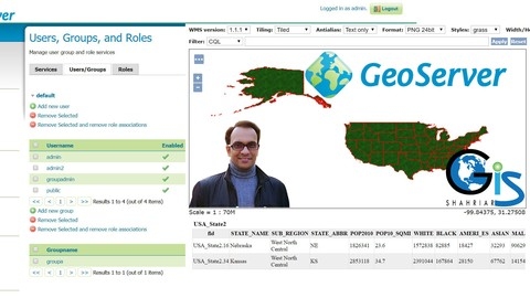
The course provides a detailed overview of the GeoServer Web Admin page, where you can manage data, styles, and user permissions.
You will learn how to work with WMS and WFS services in popular GIS software like QGIS and ArcGIS, enabling you to visualize and interact with geospatial data served by GeoServer.
The course covers advanced topics like creating users, groups, and roles in GeoServer, and how QGIS interacts with these permissions.
You will explore the inner workings of GeoServer, including HTTP requests, parameter changes using Layer Preview, and the organization of data and settings.
One of the highlights of the course is working with the DJ Basin dataset, a real-world example that will help you understand how to add your own data to GeoServer in the cloud.
You will learn how to save styles as SLD files using QGIS, create new data stores, layers, and layer groups, and test editing and user roles within QGIS.
The course delves into powerful filtering techniques, such as SQL views, parameterized SQL views, and CQL filters, allowing you to fine-tune the data served by GeoServer.
You will also learn about web-based GIS applications and how to integrate WMS and WFS data into them using technologies like Leaflet and the qgis2web plugin.
Throughout the course, you will gain experience with various web technologies, including XML, GeoJSON, and FTP, which are essential for working with geospatial data on the web.
You will even learn how to use Google Earth as a WMS client and explore the anatomy of URLs.
GeoServer Level 1: Web GIS & Server Management
You’ll start by diving into the fundamentals of web GIS, understanding its advantages, and exploring open-source web GIS solutions.
This lays the groundwork for the rest of the course, which focuses on GeoServer, a powerful open-source software for publishing spatial data.
The course walks you through installing GeoServer step-by-step, from setting up an Oracle account and Java Runtime Environment (JRE) to the actual installation process.
You’ll get hands-on experience with the GeoServer interface, learning how to navigate its different sections and perform essential tasks like uploading shapefiles, creating workspaces and stores, and publishing layers.
You’ll also learn how to publish web maps using GeoServer and share them with others using OpenLayers, an open-source JavaScript library for web mapping.
The course covers user account management, teaching you how to create different user roles, manage public and admin users, and set up user groups with varying permissions.
This is particularly useful if you plan to collaborate with others or need to control access to your GeoServer instance.
Beyond the core functionality, the course also delves into advanced topics like editing workspaces, stores, and layers, as well as server status monitoring and troubleshooting.
You’ll even learn some tips and tricks for solving common issues and accessing GeoServer instances without an account.
Throughout the course, you’ll have the opportunity to reinforce your learning with quizzes and a final assignment, ensuring you’ve mastered the material before moving on.
Learning the Open Source GIS Stack: Web Mapping w/ Geoserver
You’ll start by learning about the different strategies for implementing internet-based GIS and getting introduced to the data you’ll be working with.
From there, you’ll dive into installing and configuring the necessary software like Geoserver, Postgres, and QGIS.
Once you have the setup ready, the course will guide you through loading data into Postgres and getting started with Geoserver.
You’ll learn how to navigate the interface, create workspaces and stores, add layers from different stores, and style those layers.
A key aspect of the course is understanding services in Geoserver, particularly WMS and WFS.
You’ll also explore server-side processing, modifying data with CQL, passing variables to the server, and working with Postgres views.
The real power comes when you start integrating Geoserver with client-side technologies like OpenLayers 3.
You’ll build a basic OpenLayers map and learn how to request specific data from Geoserver using OpenLayers.
The course covers using CQL and OpenLayers to request ad-hoc data, allowing users to control their experience, and triggering Geoserver responses based on mouse interactions.
Moreover, you’ll learn how to add vector data from Geoserver to your OpenLayers application and perform spatial analysis on the server, sending the results back to the client.
This course truly takes you from the fundamentals to advanced techniques, ensuring you have a solid grasp of the open source GIS stack for web mapping.