Geographic Information Systems (GIS) are revolutionizing how we understand and interact with the world around us.
By combining geographical data with powerful software tools, GIS allows us to analyze spatial patterns, create informative maps, and make informed decisions across various fields like urban planning, environmental management, and disaster response.
Learning GIS can open doors to exciting career opportunities and empower you to contribute to solving real-world problems with spatial insights.
Finding a comprehensive and engaging GIS course can be challenging, especially with the abundance of options available online.
You’re searching for a course that strikes the right balance between theory and practice, provides hands-on experience with industry-standard software, and is taught by experts who can guide you through the complexities of spatial analysis.
Based on our thorough review of numerous courses, we believe An introduction to GIS and QGIS 3 stands out as the best overall GIS course on Udemy.
This course provides a solid foundation in GIS principles while offering practical experience with QGIS, a popular open-source GIS software.
You’ll learn everything from basic concepts like map projections and data layers to advanced techniques for spatial analysis and cartography.
However, this is just one of many excellent GIS courses available on Udemy.
If you’re looking for something more specialized, such as courses focusing on specific GIS software like ArcGIS or advanced spatial analysis techniques, we’ve got you covered.
Continue reading to explore our curated list of recommendations and find the perfect GIS course to embark on your learning journey.
An introduction to GIS and QGIS 3

This course takes you on a journey into the world of Geographic Information Systems, starting with the very basics.
You learn about important ideas like data layers, projections (think of them as different ways to flatten the Earth onto a map), and attribute tables (like spreadsheets attached to maps).
You don’t just learn the theory, you also get your hands dirty with the free and powerful QGIS software.
You’ll discover how to download data, make sure it’s accurate, and then bring it into QGIS.
Imagine opening a map of your city, zooming in on your neighborhood, and then styling the parks green and the rivers blue.
You learn how to do all of that!
This course teaches you how to ask the map specific questions, like finding all the houses built before a certain date or highlighting areas with high population density.
You even discover how to make professional-looking maps with different colors and symbols to tell a story with your data.
Core Spatial Data Analysis: Introductory GIS with R and QGIS
You’ll start by learning the fundamentals of spatial data analysis and relevant concepts.
Then, you’ll dive into working with raster data, mastering skills like reading and modifying raster bands, false color composites, band arithmetic, reclassifying to categorical rasters, resampling, clipping, and deriving topographic products.
The course also focuses on vector data, teaching you how to read and explore shapefiles, create visualizations, subset and split data, and perform basic analysis.
Additionally, you’ll learn about built-in geospatial datasets in R, Open Street Maps, GitHub, and even a Brazil time-lapse project.
Throughout the course, you’ll gain hands-on experience with both R and QGIS, two powerful tools for spatial analysis.
You’ll learn how to assign legends in QGIS and work with POSIT, a platform for sharing code and collaborating.
The course covers a wide range of techniques, from basic statistics calculations on rasters to working with raster stacks, categorical rasters, and CRS modifications.
ArcGIS Desktop For Spatial Analysis: Go From Basic To Pro

The course starts by introducing spatial data analysis concepts and providing access to tutorial data.
This lays the foundation for working with ArcGIS Desktop, the powerful geographic information system (GIS) software.
You’ll dive into ArcGIS Desktop’s functionality, learning how to access spatial data, make selections, zoom and measure, and handle different coordinate systems.
The course then covers working with raster data in ArcGIS, including displaying, merging, and performing band arithmetic on rasters.
You’ll also learn topographic calculations, zonal statistics, and geo-referencing rasters.
These skills are essential for analyzing elevation and terrain data.
Moving on to vector data, you’ll explore exploratory data analysis with shapefile attributes, spatial joins, creating choropleth maps, and various geoprocessing tasks like clipping, intersecting, and buffering shapefiles.
This section equips you with the tools to analyze and manipulate vector spatial data effectively.
The course also delves into advanced geoprocessing tasks like euclidean distance raster generation, density analysis, interpolation, and mapping spatial clusters.
You’ll even learn about geographically weighted regression, a powerful statistical technique for spatial analysis.
To streamline your workflows, you’ll learn how to use Model Builder in ArcGIS to automate geoprocessing tasks.
This can save you significant time and effort when working with large datasets.
Finally, the course covers map making in ArcGIS, teaching you how to present spatial data effectively using layers, basemaps, and cartographic design principles.
You’ll be able to create professional-looking maps that communicate your analysis results clearly.
ArcPy for Python Developers using ArcGIS Pro
This course will equip you with the skills to unlock the full potential of ArcGIS Pro through the power of ArcPy, Python’s robust GIS library.
You’ll be able to automate your workflows, perform complex analysis, and create stunning maps with unparalleled efficiency.
You’ll start by mastering the fundamentals of ArcPy, ArcGIS Pro, and spatial data.
You’ll learn how to write basic Python scripts and leverage the Python window to interact with ArcGIS Pro directly.
But this is just the beginning.
Prepare to delve deeper into the intricacies of geoprocessing.
You’ll master environmental settings, enabling you to control workspace, output locations, and other crucial aspects of your projects.
You’ll learn how to wield the power of ModelBuilder to construct complex workflows, then seamlessly integrate Python scripts for ultimate control.
The course dives into the hands-on world of data manipulation.
You’ll learn how to access and modify data in feature classes, effortlessly creating and manipulating geometry objects.
You’ll master cursors for data editing, explore the advanced data access module (arcpy.da), and gain proficiency in performing calculations with spatial data.
The power of visualization is at your fingertips with the mapping module (arcpy.mp).
You’ll learn to programmatically create and customize maps in ArcGIS Pro, adding text, graphics, pictures, and map surrounds to achieve stunning visual impact.
You’ll discover how to craft dynamic maps and map series, harnessing bookmarks to effortlessly create PDF map books.
The course will teach you how to leverage the Cartographic Information Model (CIM) to fine-tune the symbology of your maps, giving you precise control over the visual representation of your data.
You’ll have a solid foundation to build upon, ready to explore the boundless possibilities of ArcPy and Python development within the ArcGIS Pro environment.
Introduction to web programming for GIS applications
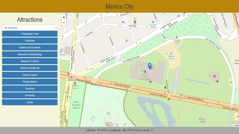
This course equips you with the basics of web programming, specifically for Geographic Information Systems (GIS).
You begin by mastering the core languages of the web: HTML for structuring content, CSS for visual styling, and JavaScript for interactivity.
You’ll grasp how these languages work together to create dynamic web pages.
You then delve into the world of GIS on the web.
You learn to use GeoJSON, the standard format for representing geographic data.
Using libraries like Leaflet, you create interactive maps directly in the browser, pulling data from GeoJSON files.
You then transition to server-side technologies, learning how to use databases like PostgreSQL with its PostGIS extension to store, manage, and query spatial data using SQL.
You discover how to build dynamic web applications that interact with these databases using PHP and AJAX, enabling seamless communication between the user’s browser and the server.
Finally, you build a complete client-server web application that interacts with a PostGIS database.
This project allows you to apply your knowledge of HTML, CSS, JavaScript, SQL, and PHP to create a functional GIS application.
The course also includes bonus lectures on mobile application design, tools like QGIS and pgAdmin, and further resources to enhance your learning experience.
Introduction to Spatial Databases with PostGIS and QGIS 3
You’ll start by learning the basics, understanding what spatial databases are, how they work, and why they’re so useful for handling geographic data.
The course then guides you through the installation of PostGIS and QGIS on your computer, two powerful tools that will become your go-to for spatial data management and analysis.
With the tools set up, you’ll learn how to load both spatial and non-spatial data into PostGIS.
The course then introduces you to SQL, the language used to communicate with databases.
You’ll master the art of writing SQL queries to retrieve, modify, and analyze data, including working with multiple tables and understanding different data types.
You’ll then explore the spatial capabilities of SQL, learning how to write queries that deal specifically with geometries like points, lines, and polygons.
The course guides you through using SQL to define your database’s structure, creating tables, establishing relationships between them, defining indexes for faster searches, and even creating your own custom data types.
You’ll become comfortable manipulating data within your database, adding new records, modifying existing ones, and deleting data.
You’ll discover how to control who has access to your database using roles and permissions.
You’ll learn to streamline your database tasks with automation techniques.
Finally, the course prepares you for the real world by teaching you how to deploy your database to a web hosting service or a cloud platform like AcuGIS Cloud.
You’ll also learn valuable techniques for optimizing the performance of your database to ensure it runs smoothly and efficiently.
QGIS 3.10 LTR for GIS Professionals
This QGIS course starts with the basics, like installing the software and navigating the interface.
You will learn how to use tools like toolbars, panels, and plugins, which add extra functions.
You need to understand coordinate reference systems, so you will learn how to use them to measure locations and identify where things are on a map.
You will also get to practice basic skills, like panning and zooming around a map and saving your work.
Next, you learn to bring data into QGIS.
The course covers different file formats, such as Shapefiles, GeoJSON, GPX, and KML.
You’ll also learn how to connect to databases, including ESRI File Geodatabases, SpatiaLite, and GeoPackages.
You will even learn to load data from online sources like PostGIS and use background maps from OpenLayers and XYZ tiles.
Then, you will explore attribute data, the information tied to map features.
You will learn to view, edit, and even calculate new information from existing data, learning how to select map features based on their attributes, spatial relationships, and filters.
You will be able to create visually appealing maps using categories, quantities, and rules.
You will also master adding labels, working with rasters, and making maps ready for printing.
The course will teach you how to create maps with elements like scale bars, north arrows, legends, and locator maps.
You will then learn to create and edit vector data, building new layers and editing points, lines, and polygons.
You will learn about topology, ensuring your data is accurate.
You will explore joins and relates, connecting data from different sources.
You will be able to perform spatial analysis, such as creating buffers, clipping, and intersecting data.
You will also learn how to summarize statistics, dissolve features, and use geometric difference tools.
The course teaches you how to analyze real-world surfaces and elevation data and how to use the Raster Calculator to make contour lines.
You will learn to convert vector layers to raster layers and how to reclassify grids.
Finally, you’ll learn about raster modeling techniques.
You’ll even learn to publish your maps online using the QGIS2Web plugin.
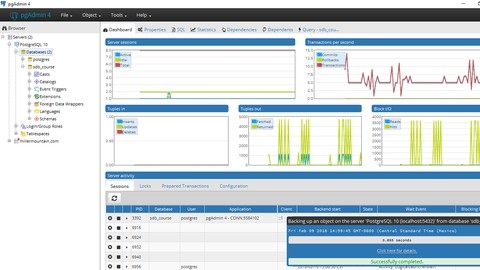
Using Open Source Tools to Create an Enterprise GIS
This course teaches you how to build a system that can handle multiple users working on data at the same time.
You will begin by setting up your system with QGIS and PostGRES.
You will learn how to install, manage, and secure your data using PostGRES.
You will even create custom views to visualize data in QGIS.
Next, you will go beyond the basics and learn how to analyze data using QGIS plugins.
You will edit data directly in PostGRES, and even create triggers to automate tasks.
This is where you gain a serious advantage, becoming one of the few who can understand and manipulate data at this level.
Finally, you will discover how to deploy your enterprise GIS and make it available to others.
You will even explore server-side analysis, a critical skill for advanced GIS.
Imagine creating your own custom external programs that can interact with your PostGRES database - a skill few possess.
Also check our posts on: